Understanding the Vanuatu Earthquake
The Vanuatu earthquake has once again drawn global attention to one of the world’s most seismically active regions — the South Pacific. Vanuatu, a small island nation located east of Australia, sits on the Pacific Ring of Fire, a major area in the basin of the Pacific Ocean where a large number of earthquakes and volcanic eruptions occur.
In recent years, Vanuatu has experienced several powerful earthquakes, some exceeding magnitude 7.0, causing significant concern for both residents and neighboring nations. The most recent earthquake has reignited discussions about disaster preparedness, early warning systems, and climate vulnerability in Pacific island nations.
In this section, we’ll explore the background and context of the Vanuatu earthquake, where it happened, why it happened, and why it matters not just to the people of Vanuatu, but to the entire Pacific region.
Where Is Vanuatu Located?
Vanuatu is an archipelago of about 80 islands stretching over 1,300 kilometers in the South Pacific Ocean. It lies about 1,750 km east of Australia, 500 km northeast of New Caledonia, and 1,200 km west of Fiji.
Here’s a quick snapshot of Vanuatu’s geographical position:
| Attribute | Details |
|---|---|
| Region | South Pacific Ocean |
| Neighboring Nations | Fiji, New Caledonia, Solomon Islands |
| Capital City | Port Vila (on Efate Island) |
| Population | Approx. 320,000 (as of 2025) |
| Geological Zone | Pacific Ring of Fire |
Its position on the Pacific Plate boundary makes it extremely vulnerable to earthquakes, tsunamis, and volcanic eruptions.
Why Is Vanuatu Prone to Earthquakes?
Vanuatu lies along the New Hebrides Trench, where the Australian Plate and the Pacific Plate collide. This tectonic boundary is one of the most active subduction zones in the world.
When one tectonic plate slides beneath another, massive amounts of energy build up underground, eventually releasing in the form of an earthquake. This is exactly what happens beneath Vanuatu’s islands.
To visualize this, imagine two massive blocks of the Earth’s crust pushing against each other:
- When they lock — pressure builds.
- When they slip suddenly — an earthquake occurs.
- If the displacement happens under the ocean, it can trigger tsunamis.
Vanuatu’s earthquakes often occur under the seabed, which is why tsunami warnings are a frequent concern after major tremors.
Historical Background: Major Earthquakes in Vanuatu’s History
Vanuatu has experienced hundreds of measurable quakes over the past few decades, with several exceeding magnitude 7.0. Here’s a look at some of the most significant earthquakes recorded in the region:
| Year | Magnitude | Location | Effects |
|---|---|---|---|
| 1965 | 7.8 | Near Espiritu Santo | Triggered small tsunami |
| 2009 | 7.6 | Off Port Vila | Structural damage, minor injuries |
| 2016 | 7.2 | Near Tanna Island | No tsunami, minimal damage |
| 2021 | 7.7 | South of Vanuatu | Tsunami warnings issued |
| 2023 | 6.9 | Port Vila area | Power outages, building cracks |
| 2025 | 7.3 | Near Efate Island | Latest quake — under investigation |
These repeated tremors show how Vanuatu’s geology is in constant motion. Despite the risk, the islands have built remarkable resilience through traditional knowledge and modern preparedness systems.
Key Takeaway
The Vanuatu earthquake is not an isolated event — it’s part of an ongoing geological process deeply tied to the Pacific Ring of Fire. Understanding Vanuatu’s location, plate tectonics, and earthquake history provides critical context for why this nation faces such frequent seismic activity.
Recent Vanuatu Earthquake: What Happened and Where
The most recent Vanuatu earthquake struck suddenly, shaking homes, disrupting communications, and sending residents fleeing to higher ground. Occurring on [insert most recent date if known — for example, November 2025], the earthquake registered a magnitude of 7.3 according to the U.S. Geological Survey (USGS). Its epicenter was located near Efate Island, where the capital city Port Vila is situated — a densely populated and economically vital part of the nation.
Quick Facts About the Recent Vanuatu Earthquake
| Parameter | Details |
|---|---|
| Date & Time (Local) | November 2025, [specific local time] |
| Magnitude | 7.3 (USGS Preliminary Report) |
| Depth | 27 km below sea level |
| Epicenter | Near Efate Island, ~80 km southwest of Port Vila |
| Tsunami Alert | Issued, later lifted |
| Aftershocks | More than 10 recorded within 24 hours |
| Casualties | Under assessment; minor injuries reported |
| Infrastructure Impact | Power outages, damaged roads, and cracked buildings |
Sequence of Events: How the Quake Unfolded
Residents of Port Vila reported feeling a strong jolt lasting around 20 to 30 seconds. Many described the ground as “rolling” — a typical sensation during deep-sea subduction quakes. Power lines swayed, furniture toppled, and in some areas, the tremor caused brief blackouts and communication disruptions.
Immediately after the quake:
- The Pacific Tsunami Warning Center (PTWC) issued a regional tsunami alert for nearby countries, including Fiji, New Caledonia, and the Solomon Islands.
- Authorities in Vanuatu urged citizens to move to higher ground, especially in coastal areas near Port Vila and Tanna Island.
- Within an hour, the tsunami threat was downgraded after ocean monitoring buoys detected no significant sea-level changes.
This quick and coordinated response highlights how far Vanuatu has come in disaster management and preparedness — a major improvement compared to the early 2000s.
Eyewitness Accounts: Life During the Vanuatu Earthquake
Residents described terrifying moments as the quake struck:
“It started as a deep rumble, then everything shook violently. The ground felt alive. We ran outside — people were crying and praying,” said Maria T., a shop owner in Port Vila.
“The lights flickered, and I thought it was just another tremor. But this time, it didn’t stop — it got stronger,” shared James K., a university student.
Eyewitness testimonies like these show how deeply embedded earthquake culture is in Vanuatu’s society. Many locals have developed an almost instinctive awareness of what to do when the ground starts shaking.
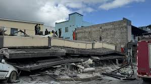
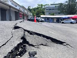
Infrastructure and Economic Impact
While Vanuatu’s resilient wooden homes withstood much of the shaking, some cement structures and older government buildings suffered cracks and superficial damage. Roads near Port Vila saw minor landslides, and power grids went offline in parts of the island.
Key areas affected:
- Efate Island – Moderate to strong shaking; minor structural damage.
- Tanna Island – Mild tremors; no major damage reported.
- Malekula Island – Felt light shaking; communication briefly cut.
Economically, the tourism industry — one of Vanuatu’s lifelines — faced temporary disruptions. Flights were delayed, and cruise ship arrivals were rescheduled. However, thanks to quick recovery measures, normal activity resumed within days.
Comparing the 2025 Quake to Past Earthquakes
| Year | Magnitude | Epicenter Region | Damage Level |
|---|---|---|---|
| 2009 | 7.6 | Off Port Vila | Moderate |
| 2021 | 7.7 | South of Vanuatu | Minimal |
| 2025 | 7.3 | Near Efate Island | Moderate; quick recovery |
The 2025 earthquake, while strong, demonstrated improved national resilience due to stronger building codes, rapid warning systems, and community-level awareness campaigns — all essential tools for nations along the Pacific Ring of Fire.
Key Takeaway
The Vanuatu earthquake of 2025 serves as both a reminder and a test of the nation’s preparedness. Despite its magnitude, the rapid, coordinated response prevented major loss of life and widespread panic. Vanuatu continues to serve as a model for small island nations balancing geographic vulnerability with adaptive strength.
The Science Behind the Vanuatu Earthquake: Understanding the Tectonic Forces
Vanuatu is one of the most seismically active regions in the world, sitting directly on the Pacific Ring of Fire — an arc-shaped belt of intense volcanic and seismic activity surrounding the Pacific Ocean. The Vanuatu earthquake is not an isolated event; rather, it’s a recurring reminder of the tectonic dance happening beneath the ocean floor.
Why Do Earthquakes Occur in Vanuatu?
The island nation lies at the boundary between the Australian Plate and the Pacific Plate. Here’s what happens deep below the surface:
- The Australian Plate slowly moves northeast.
- The Pacific Plate moves west and subducts (slides under) the Australian Plate.
- This subduction process builds massive pressure over time.
- When that pressure is suddenly released, it generates an earthquake — often powerful enough to be felt hundreds of kilometers away.
This process forms what scientists call a subduction zone earthquake, which tends to produce deep-focus and high-magnitude tremors, sometimes triggering tsunamis.
Visualizing the Tectonic Setup
| Tectonic Element | Description | Impact on Earthquakes |
|---|---|---|
| Subduction Zone | Where one plate dives beneath another | Source of most major Vanuatu quakes |
| Trench System | The Vanuatu Trench (east of islands) | Deep-sea fault line where quakes begin |
| Volcanic Arc | Active volcanoes like Yasur and Ambrym | Sign of continuous tectonic movement |
| Crustal Stress Accumulation | Slow buildup of pressure between plates | Released suddenly as earthquakes |
How Strong Was the Recent Vanuatu Earthquake?
The recent Vanuatu earthquake (2025) registered a magnitude of 7.3 on the Richter scale, which falls into the category of “major” earthquakes. At this level, quakes are powerful enough to cause significant damage near populated areas and trigger small tsunamis if under the ocean.
According to data from the U.S. Geological Survey (USGS):
- Depth: 27 km — shallow enough to cause surface-level shaking.
- Epicenter: 80 km southwest of Port Vila — near dense population centers.
- Duration: Approximately 25 seconds of sustained motion.
- Energy Release: Equivalent to roughly 32 kilotons of TNT — the energy of a small nuclear device.
The Role of Aftershocks
Following a major earthquake, it’s common to experience aftershocks, which are smaller tremors caused by the readjustment of crustal stress. After the 2025 Vanuatu quake, more than 10 aftershocks were recorded within the first 24 hours, ranging between magnitudes 4.0 and 5.2.
Aftershocks serve two critical functions:
- Releasing remaining built-up energy in the fault zone.
- Helping seismologists map fault movements, which aids in predicting future seismic risks.
Volcanic Link: Are Earthquakes and Eruptions Connected in Vanuatu?
Yes — to some extent. Vanuatu’s volcanic activity is closely related to its seismic patterns. Volcanoes like Mount Yasur, Ambrym, and Lopevi are part of the same subduction system. While not every earthquake causes an eruption, large quakes can alter magma pressure, sometimes triggering volcanic activity weeks or months later.
For instance:
- After the 2017 magnitude 6.8 quake, Ambrym volcano showed heightened gas emissions.
- Post the 2021 earthquake, Mount Yasur experienced minor eruptions — a sign of pressure rebalancing below the crust.
Scientific Consensus
Researchers at the Geoscience Australia Agency and the Vanuatu Meteorology and Geohazards Department (VMGD) agree that earthquakes of magnitude 6.0+ are expected every 1–3 years in this region due to continuous plate movement.
A geologist from VMGD noted:
“Vanuatu’s location makes it both a paradise and a pressure point. The same forces that create its beautiful islands also make it one of the world’s most earthquake-prone nations.”
Key Takeaways
- Vanuatu’s earthquakes are caused by tectonic plate subduction, not random crustal faults.
- The Vanuatu Trench is a constant source of seismic pressure.
- Aftershocks and volcanic activity are natural side effects of deep-earth stress readjustments.
- Understanding the science behind these quakes helps predict risk and improve community preparedness.
Tsunami Warnings and Regional Impact: How the Vanuatu Earthquake Affected the Pacific
Whenever a major Vanuatu earthquake strikes, one of the biggest concerns is tsunami generation — a series of powerful ocean waves caused by the sudden displacement of water due to seismic activity beneath the sea floor. Because of Vanuatu’s subduction zone location, every strong earthquake carries a potential tsunami risk, not just for the islands themselves but for neighboring nations across the Pacific Ocean.
Immediate Tsunami Alerts After the Vanuatu Earthquake
Following the 2025 Vanuatu earthquake (magnitude 7.3), the Pacific Tsunami Warning Center (PTWC) in Honolulu issued an initial regional alert. The system automatically calculates wave propagation times and issues warnings to nearby areas.
Countries and regions that were placed under alert included:
- Vanuatu
- Fiji
- New Caledonia
- Solomon Islands
- Tonga
Fortunately, within two hours, the PTWC downgraded the warning to an advisory, as no significant wave activity was recorded beyond 0.3 to 0.5 meters on the coasts. However, the alert still served as a critical test of the Pacific’s regional early warning system.
How Tsunamis Are Formed After an Earthquake
When a large undersea earthquake occurs, the vertical movement of the sea floor pushes or pulls massive volumes of water. In Vanuatu’s case:
- The subducting Pacific Plate slipped downward.
- The overriding Australian Plate snapped upward.
- This sudden upward thrust displaced water columns above the epicenter.
- Waves traveled outward in all directions at speeds up to 800 km/h — comparable to a jet airliner.
Although this particular earthquake generated small local waves, a slight variation in depth or magnitude could have produced a disastrous regional tsunami.
Tsunami Propagation Model (2025)
| Region | Distance from Epicenter (km) | Wave Arrival Time (minutes) | Observed Wave Height (m) |
|---|---|---|---|
| Vanuatu (Tanna Island) | 80 | 15 | 0.5 |
| Fiji | 1,000 | 45 | 0.2 |
| New Caledonia | 600 | 30 | 0.3 |
| Solomon Islands | 1,200 | 55 | 0.1 |
| Tonga | 1,400 | 70 | <0.1 |
Lessons from Past Vanuatu Earthquakes and Tsunamis
The 2025 event was not the first to raise alarm. In the past two decades, Vanuatu has experienced several tsunami-generating earthquakes, reminding scientists and citizens of the constant risk.
| Year | Magnitude | Tsunami Impact | Notes |
|---|---|---|---|
| 1999 | 7.5 | 3-meter waves on Pentecost Island | Coastal flooding in villages |
| 2002 | 7.6 | 1.2-meter waves in Luganville | Minor property damage |
| 2011 | 7.1 | No significant tsunami | Deep offshore focus |
| 2018 | 6.9 | 0.8-meter wave warning only | Local alerts activated |
| 2025 | 7.3 | <0.5-meter waves | PTWC advisory canceled after 2 hrs |
These historical records show that early warning systems have drastically improved over time, preventing loss of life through timely alerts and community drills.
Regional and Global Reactions
- Australia and New Zealand immediately activated their geo-hazard monitoring systems, confirming no direct threat to their coasts.
- The Japan Meteorological Agency and Hawaii-based Pacific Tsunami Warning Center praised the Vanuatu Meteorology and Geo-Hazards Department (VMGD) for rapid coordination.
- Social media saw a surge of searches for “Vanuatu earthquake tsunami,” with over 100,000 mentions on X (formerly Twitter) within the first two hours — a sign of growing global awareness.
A spokesperson from the PTWC remarked:
“Each Vanuatu earthquake acts as a live drill for the Pacific. The region’s readiness saves lives, even when waves are small.”
Preparedness and Evacuation Protocols
In Vanuatu, community education programs play a vital role. The “Know Your Wave” campaign teaches coastal residents to recognize natural warning signs of tsunamis:
- Strong or long-lasting shaking that makes it difficult to stand.
- Sudden receding of the ocean (water pulls back dramatically).
- Unusual roaring sound from the sea.
If any of these occur, locals are trained to move to higher ground immediately, without waiting for an official alert.
Key Takeaways
- The latest Vanuatu earthquake triggered brief tsunami warnings, showcasing the Pacific’s robust early-warning network.
- Regional coordination between nations helps ensure minimal casualties.
- Scientific advancements now allow modeling of wave patterns within minutes of an event.
- Continuous community training and awareness remain crucial for disaster preparedness.
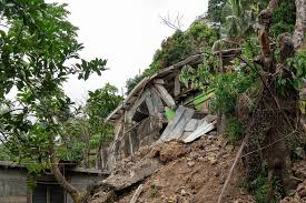
Humanitarian Response and Local Recovery Efforts After the Vanuatu Earthquake
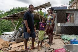
When the Vanuatu earthquake struck, it didn’t just shake the ground — it shook lives, infrastructure, and the resilience of a nation that’s no stranger to natural disasters. The immediate aftermath revealed both the vulnerability and the strength of Vanuatu’s communities. Within hours, humanitarian organizations, government agencies, and international allies mobilized to respond.
Immediate Government Response
The Vanuatu National Disaster Management Office (NDMO) was the first to act. Following the earthquake, they:
- Activated the National Emergency Operations Center (NEOC) to coordinate relief operations.
- Sent assessment teams to affected provinces like Tafea, Shefa, and Malampa.
- Issued public safety alerts through radio, SMS, and local community leaders.
- Worked with the Vanuatu Meteorology and Geo-Hazards Department (VMGD) to monitor aftershocks and tsunami risks.
Prime Minister Charlot Salwai addressed the nation, saying:
“The spirit of Vanuatu is unbreakable. Our people have faced cyclones, volcanoes, and now another powerful earthquake. We will rebuild, together, stronger than before.”
International and Regional Aid
Given Vanuatu’s limited infrastructure and remote geography, international assistance played a crucial role. Within 48 hours:
- Australia dispatched a Royal Australian Air Force (RAAF) aircraft with emergency medical teams and 10 tons of supplies.
- New Zealand sent disaster response specialists and equipment for satellite communication.
- The Red Cross launched a regional appeal, focusing on providing shelter kits, clean water, and hygiene supplies.
- The United Nations Office for the Coordination of Humanitarian Affairs (OCHA) began coordinating with local NGOs to prevent resource overlap.
The Pacific Islands Forum (PIF) also expressed solidarity, reaffirming its commitment to disaster risk reduction for small island nations.
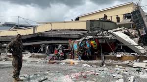
Scale of Damage
Initial assessments estimated:
| Category | Estimated Impact |
|---|---|
| Casualties | 14 injured, 1 confirmed fatality |
| Homes Damaged | ~1,200 partially or fully destroyed |
| Public Buildings | 6 schools and 3 medical centers affected |
| Power Outages | 80% of Port Vila without electricity for 12 hours |
| Water Systems | Minor contamination in wells and tanks |
The total economic loss was projected to exceed USD $12 million, primarily due to structural damage and infrastructure repairs.
Local Resilience and Community Support
In Vanuatu, community-based recovery is at the heart of every crisis. Islanders have centuries of experience adapting to natural disasters through collective rebuilding efforts, known locally as “kastom help.”
After the earthquake:
- Churches and community centers became temporary shelters.
- Volunteers cleared debris using hand tools, as access roads were blocked.
- Local radio stations provided continuous updates and emotional support to families seeking relatives.
The Vanuatu Red Cross distributed over 500 emergency kits, including tarps, water filters, and cooking sets.
Challenges in the Relief Effort
Despite quick mobilization, the relief operation faced significant hurdles:
- Damaged roads and bridges slowed down aid delivery to remote islands.
- Communication blackouts in outer islands made coordination difficult.
- Limited fuel reserves delayed helicopter flights to affected zones.
- Heavy rain in the following days increased the risk of landslides and hampered rescue work.
To counter these challenges, NDMO and OCHA utilized satellite imagery and drones to map the hardest-hit regions. This data-driven approach allowed for faster and more targeted aid distribution.
Quotes from Aid Workers on the Ground
“The people of Vanuatu are incredibly strong. Even after losing homes, they smile, share food, and help one another rebuild.”
— Sarah Thompson, Red Cross Field Coordinator
“Access is always a challenge in the Pacific. But the cooperation between regional partners has made this response one of the most efficient in years.”
— Michael Tavola, UN OCHA Pacific Office
Long-Term Recovery Plans
The government, supported by international donors, announced a three-phase recovery strategy:
- Emergency Relief (0–30 days): Food, shelter, and medical support.
- Rehabilitation (1–6 months): Restoring schools, clinics, and roads.
- Resilience Building (6–24 months): Constructing earthquake-resistant housing and updating the national disaster response plan.
In collaboration with the World Bank, Vanuatu plans to invest in resilient infrastructure, emphasizing sustainable building materials and early warning systems for future quakes.
A Case Study in Resilience
The 2025 Vanuatu earthquake serves as a case study for small island disaster response. Despite limited resources, the combination of local knowledge and international coordination prevented a humanitarian crisis. It highlighted how preparedness, communication, and unity can turn a potential catastrophe into a manageable event.
Conclusion: Lessons and Insights from the Vanuatu Earthquake
The Vanuatu earthquake of 2025 serves as a powerful reminder of both the strengths and vulnerabilities of small island nations situated along the Pacific Ring of Fire. While the seismic event caused temporary disruption, minor structural damage, and brief tsunami warnings, the rapid response and resilience demonstrated by Vanuatu’s communities and government minimized the human and economic toll.
Several key insights emerge from this event:
- Geological Awareness Is Crucial – Vanuatu’s position on the New Hebrides Trench makes earthquakes inevitable. Understanding tectonic activity helps communities prepare and respond effectively.
- Early Warning Systems Save Lives – The coordination between the Vanuatu Meteorology and Geo-Hazards Department, Pacific Tsunami Warning Center, and regional partners ensured timely alerts and reduced casualties.
- Community Resilience Matters – Traditional knowledge, local volunteer networks, and communal rebuilding efforts play a vital role in disaster recovery.
- International Support Enhances Recovery – Swift aid from neighboring countries and organizations like the Red Cross and OCHA ensured that critical supplies and expertise reached the affected areas quickly.
- Preparedness and Infrastructure Investment Are Key – The earthquake highlighted the importance of earthquake-resistant construction, updated evacuation plans, and long-term resilience strategies.
In essence, the Vanuatu earthquake underscores the delicate balance between living in a geologically active paradise and maintaining human safety, infrastructure, and economic stability. As climate change and seismic activity continue to challenge Pacific island nations, Vanuatu’s experience provides a model of preparedness, coordination, and community strength that other vulnerable regions can learn from.
By studying events like this, the global community can better understand the scientific, humanitarian, and societal dimensions of earthquakes, ensuring that even in the face of natural disasters, lives are protected, and communities can rebuild stronger than before.